Eleven terawatt hours (TWh) is the amount of electricity to be generated from photovoltaic systems in Austria in 2030. At least that is the plan of the Renewable Energy Expansion Act (EAG), which came into force in January 2022. According to Information from Austrian Power Grid as of August 2024, there were systems across Austria with an output of around 7.3 gigawatt peak (GWp), which, depending on the actual hours of sunshine, corresponds to an annual electricity yield of 7.3 TWh. So, there is still a certain gap to close, and this cannot be realised with rooftop systems alone.
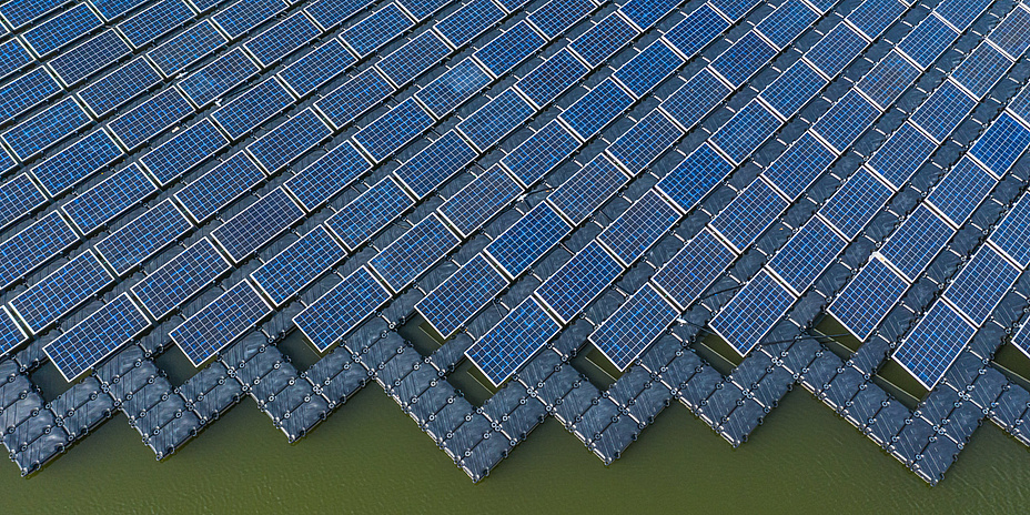
In the PV4EAG project, a consortium consisting of FH Joanneum, Graz University of Technology (TU Graz), FH Campus 02, dwh GmbH and Energieagentur Steiermark has investigated the potential for utilising alternative photovoltaic areas in Graz as well as selected municipalities in the districts of Leoben, Schladming, Murtal, Fürstenfeld and Voitsberg. The project was funded by the Austrian Research Promotion Agency (FFG). In addition to house façades as an alternative to rooftops, the team evaluated the PV potential of agricultural land, bodies of water (floating PV), car parks and noise barriers. Based on the data available to them, the researchers found alternative PV surfaces in the selected test regions with an energy yield of around 910 gigawatt hours (GWh) per year, more than half of which is attributable to building façades. As the municipalities analysed account for only a small part of Austria’s total area, there is probably still a great deal of potential lying dormant nationwide.
Weighting given to environmental, economic and social factors
The researchers paid particular attention to considering ecological, economic and social aspects in addition to the pure land potential. The aim of the study was to optimise the use of sunlight in terms of the orientation of the areas without sealing valuable areas, negatively impacting nature in general and protected areas in particular, or creating conflicts with other usage requirements. The team therefore worked with experts to develop individual criteria and weighted the PV potential of the respective areas based on their relative importance. For example, proximity to the electricity grid was an important criterion for all potential sites, while the issue of soil quality played a greater role for agricultural land.
The researchers did not simply try to categorise every free area with sufficient solar radiation as suitable for PV. And where arable land or water areas were included, there was also an exchange with experts, including regarding the appropriate technology. Transparent PV modules allow enough sunlight to reach the plants, while at the same time protecting them from frost and storms such as hail. A PV system can also have advantages for bodies of water, as it has a cooling effect on the water and results in less algae formation.
Abundance of data
In addition to these aspects, the mammoth task of PV4EAG was to track down the necessary data sources and find an evaluation method that would deliver relevant results, taking into account the criteria developed with the experts. It was important to the researchers to use freely available and public data. On the one hand, they used existing data from geographic information services (GIS) like GIS Steiermark to obtain digital building heights, terrain models or cadastral data. They combined these with open data sources such as Open StreetMap and data on land use and current agricultural land utilisation. The solar radiation data set, which was provided by the state of Carinthia and maps the solar radiation on a grid with cells measuring one square metre, was of central importance. The team supplemented this with average values from publicly available data from the PV planning service provider Solargis.
This flood of data had to be assessed for relevance, collated and ultimately utilised for the purpose of the project. Programming expertise was particularly in demand here at TU Graz, where the Institute of Geodesy, together with the Institute of Software Technology and corporate partner dwh, implemented data fusion, semantically appropriate data integration and an AI method for identifying shaded areas unsuitable for PV. From this, the project team was able to work out the geographical potential of the alternative PV areas identified and assign a score for PV suitability to each 1 x 1 metre area, taking into account the criteria of hazard zones, land use, protected areas and solar radiation. Additional criteria were added for agricultural land and floating PV. For agricultural land, these were agricultural utilisation and soil quality. Floating PV also took into account water body type, water body utilisation, size of the riparian zone, water level fluctuations and water body depth. Based on the geographical potential, the researchers at Campus02 and FH Joanneum calculated the energy potential in terms of technological feasibility. They were unable to take existing systems into account, as no data was available and the satellite images do not distinguish between PV and solar thermal systems.
Analysis for the whole of Austria theoretically possible
“With the PV4EAG project, the entire team was able to provide an important impetus for developing the potential of alternative areas for photovoltaics,” says Franziska Hübl from the Institute of Geodesy at TU Graz. “Our method of analysis is a small step towards supporting decision-makers in advancing the energy transition. The provision of relevant data sets would be another important step in this regard. The method can be extended with further criteria and, depending on the available data sets, can be transferred to the whole of Austria and other countries.”
This research is anchored in the Field of Expertise "Information, Communication & Computing", one of five strategic foci of TU Graz.
You can find more research news on Planet research. Monthly updates from the world of science at Graz University of Technology are available via the research newsletter TU Graz research monthly.
Franziska HÜBL
BSc MSc
TU Graz | Institute of Geodesy
Phone: +43 316 873 6832
franziska.huebl@tugraz.at
Philipp BERGLEZ
Univ.-Prof. Dipl.-Ing. Dr.techn.
TU Graz | Institute of Geodesy
Phone: +43 316 873 6830
pberglez@tugraz.at