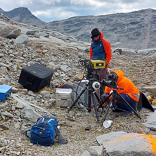
InSARTrac Mölltal Glacier measurements
InSARTrac is a hybrid 3D monitoring method developed by Mr Christoph Zambanini in his PhD research at IAG. Controlled field measurements have indicated significant potential of InSARTrac for (geotechnical) monitoring applications because of having a high accuracy and being cost-effective. InSARTrac only requires one terrestrial InSAR device and a camera used for feature tracking, instead of multiple InSAR instruments or InSAR satellite passes. Currently InSARTrac measures glacial surface displacements at the Mölltal Glacier (Carinthia, Austria). The InSARTrac 3D displacement vectors show details concerning glacial retreat dynamics related to a combination of ice flow and volume loss. Preliminary results show glacial retreats of 1.5 cm per day with the major part occurring during daytimes.
InSARTrac working principle:
The terrestrial InSAR system Hydra-G is a robust, real-time and continuous monitoring method with an intrinsic accuracy of < 0.1 mm, but only in line of sight (LoS). Feature Tracking (FT) measures object displacements in image sets with subpixel accuracy, but only normal to its LoS. The combination of the “in LoS” data (Hydra, 1D) with the “normal to the LoS” data (FT, 2D) results in 3D measurements (InSARTrac).
To establish this system merge, the Hydra and the camera are positioned in a way to have (approximately) the same LoS, monitoring the same area simultaneously, where the Hydra LoS is defined by its centre position. The initial measurement results of defined areas are vectorially combined resulting in 3D displacement vectors.


